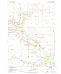
1957 Map of Riverside
USGS Topo · Published 1977About this map
The James River meanders through the heart of this mid-century landscape, defining the boundary between Davison Co and Hanson Co. The small settlement of Riverside and the adjacent Riverside Camp sit near the river's bend, where the Chicago and North Western railway cuts across the prairie. This area reflects a classic rural South Dakota development pattern, with a dense network of country schoolhouses like Riverside Sch, Bard Sch, and several numbered districts including School No 2 and School No 7. The presence of the Chicago Milwaukee St Paul and Pacific line further south highlights the era's reliance on rail transport for agricultural goods. Between the watercourses of Firesteel Creek and Enemy Creek, the land is marked by small-scale industrial features such as a Gravel Pit and a municipal Sewage Disposal site, indicating the infrastructure supporting nearby Mitchell.
Find a feature on this map
24 named features on this map. Tap any name to fly to it.
Don’t see what you’re looking for? This feature index may not catch every label — zoom into the map to look around manually.
Map Details
Editions of this 1957 Riverside Map
2 editions found
Other maps of this area

1899 · Mitchell
USGS Topo · 1:125,000

1899 · Alexandria
USGS Topo · 1:125,000

1955 · Sioux Falls
USGS Topo · 1:250,000

1955 · Mitchell
USGS Topo · 1:250,000

1957 · Alexandria
USGS Topo · 1:24,000

1957 · Ethan
USGS Topo · 1:24,000

1957 · Loomis
USGS Topo · 1:24,000

1957 · Rockport Colony
USGS Topo · 1:24,000

1957 · Riverside
USGS Topo · 1:24,000

1957 · Farwell
USGS Topo · 1:24,000