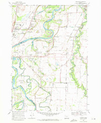
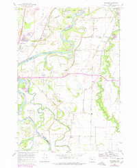
1969 Map of Riverside
USGS Topo · Published 1971About this map
The Willamette River winds through this agricultural landscape at the border of Linn and Benton Counties, defined by a complex network of active and former river channels. The riparian environment is marked by significant features like Half Moon Bend, Horseshoe Lake, and the meandering East Channel Willamette River, which separate large landmasses such as Stahlbusch Island and Kiger Island. This 1969 survey reveals a rural economy centered on the fertile valley floor, where the Oregon State Univ Experimental Farm and numerous gravel pits operate alongside the Southern Pacific and Oregon Electric rail lines.
Find a feature on this map
56 named features on this map. Tap any name to fly to it.
Don’t see what you’re looking for? This feature index may not catch every label — zoom into the map to look around manually.
Map Details
Editions of this 1969 Riverside Map
2 editions found
Other maps of this area

1911 · Tangent
USGS Topo · 1:31,680
1911 · Inavale
USGS Topo · 1:31,680

1912 · Jefferson
USGS Topo · 1:31,680

1912 · Halsey
USGS Topo · 1:62,500
1913 · Philomath
USGS Topo · 1:31,680

1913 · Oakville
USGS Topo · 1:31,680

1913 · Wells
USGS Topo · 1:31,680

1914 · Soap Creek
USGS Topo · 1:31,680

1916 · Albany
USGS Topo · 1:62,500

1921 · Corvallis
USGS Topo · 1:62,500