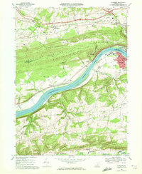
1969 Map of Riverside
USGS Topo · Published 1972About this map
The Susquehanna River carves a deep path through the center of this 1969 landscape, separating the industrial and transit corridors of Riverside and Danville Airport from the steep, wooded heights of Montour Ridge. The river valley serves as a primary artery for the Penn Central and Erie-Lackawanna railroads, while the ridges host expansive tracks of State Game Lands No 115. Local industry and infrastructure are evident at the Franklin Furnace and a Pumping Sta near the riverbank.
Find a feature on this map
49 named features on this map. Tap any name to fly to it.
Don’t see what you’re looking for? This feature index may not catch every label — zoom into the map to look around manually.
Map Details
Editions of this 1969 Riverside Map
3 editions found
Other maps of this area

1892 · Shamokin
USGS Topo · 1:62,500

1893 · Sunbury
USGS Topo · 1:62,500

1893 · Shamokin
USGS Topo · 1:62,500

1924 · Milton
USGS Topo · 1:62,500

1935 · Hughesville
USGS Topo · 1:62,500

1943 · Shamokin
USGS Topo · 1:62,500

1943 · Sunbury
USGS Topo · 1:62,500

1950 · Harrisburg
USGS Topo · 1:250,000

1952 · Shamokin
USGS Topo · 1:62,500

1953 · Hughesville
USGS Topo · 1:62,500