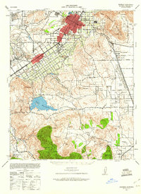
1942 Map of Riverside
USGS Topo · Published 1960About this map
The Santa Ana River winds past West Riverside and the core of Riverside, where a dense grid of streets like Magnolia Avenue and Victoria Avenue reflects the city's early expansion. During this era, the landscape transitions from the urbanized citrus belts to the sprawling military reservation of Camp Haan and the waters of Lake Mathews. Significant educational and institutional landmarks include the Sherman Institute and La Sierra College, while the agricultural character is preserved in numerous named holdings like the Morris Washington Ranch and Rancho de las Piedras. To the south, the foothills of the Box Springs Mountains give way to industrial and natural resource sites, notably the Cajalco Tin Mine and Gavilan Mine. This survey captures the region just as wartime military needs and postwar residential growth began to reshape the old ranching and mining districts.
Find a feature on this map
78 named features on this map. Tap any name to fly to it.
Don’t see what you’re looking for? This feature index may not catch every label — zoom into the map to look around manually.
Map Details
Editions of this 1942 Riverside Map
2 editions found

Other maps of this area

1896 · San Bernardino
USGS Topo · 1:62,500

1897 · Cucamonga
USGS Topo · 1:62,500

1898 · San Bernardino
USGS Topo · 1:62,500

1899 · Redlands
USGS Topo · 1:62,500

1900 · Cucamonga
USGS Topo · 1:62,500

1901 · Southern California Sheet No. 1
USGS Topo · 1:250,000

1901 · San Bernardino
USGS Topo · 1:62,500

1901 · Redlands
USGS Topo · 1:62,500

1901 · Elsinore
USGS Topo · 1:125,000

1901 · Riverside
USGS Topo · 1:62,500