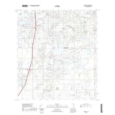
2018 Map of Riverview
USGS Topo · Published 2018About this map
The Alafia River and Bullfrog Creek systems define this 2018 survey of Riverview and its surrounding suburbs. While the town of Riverview serves as the central hub, the map reveals a complex network of residential developments that have integrated with the older rural landmarks of Hillsborough County. Local genealogists may find interest in the Samford Cem and the historical routes along Riverview Dr and Providence Rd. The waterway patterns are intricate, showing the confluence of Moody Br with the main river and the location of the Bell Shoals Bridge. The transition from established neighborhoods to smaller water features like Jerry Pond and Hutto Lake illustrates the modern landscape of this Florida community. Roadways like Albyar Ave and McMullen Loop provide additional geographic context for property research in this rapidly developing region.
Find a feature on this map
233 named features on this map. Tap any name to fly to it.
Don’t see what you’re looking for? This feature index may not catch every label — zoom into the map to look around manually.
Map Details
Editions of this 2018 Riverview Map
This is the sole edition of this map. No revisions or reprints were ever made.
Other maps of this area

1921 · Tampa
USGS Topo · 1:62,500

1944 · Mango
USGS Topo · 1:31,680

1944 · Ruskin
USGS Topo · 1:31,680

1944 · Tampa
USGS Topo · 1:31,680

1944 · Wimauma
USGS Topo · 1:31,680

1944 · Balm
USGS Topo · 1:31,680

1945 · Gadsden Point
USGS Topo · 1:31,680
1947 · Tampa
USGS Topo · 1:25,000

1947 · Ruskin
USGS Topo · 1:25,000

1947 · Wimauma
USGS Topo · 1:25,000