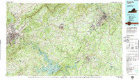
1985 Map of Roanoke
USGS Topo · Published 1989About this map
The Roanoke River system anchors this mid-1980s landscape, featuring the expansive waters of Smith Mountain Lake and the adjacent Leesville Lake. The map illustrates a region defined by its prominent topography, from Tinker Mountain in the west to the iconic Peaks of Otter near the center. The Blue Ridge Parkway winds along the high ridges, providing a scenic backbone that connects the Jefferson National Forest with the major urban centers of Roanoke and Lynchburg.
Find a feature on this map
112 named features on this map. Tap any name to fly to it.
Don’t see what you’re looking for? This feature index may not catch every label — zoom into the map to look around manually.
Map Details
Editions of this 1985 Roanoke Map
2 editions found
Other maps of this area

1887 · Lewisburg
USGS Topo · 1:125,000

1890 · Roanoke
USGS Topo · 1:125,000

1890 · Christiansburg
USGS Topo · 1:125,000

1891 · Roanoke
USGS Topo · 1:125,000

1891 · Lewisburg
USGS Topo · 1:125,000

1892 · Lynchburg
USGS Topo · 1:125,000

1892 · Buckingham
USGS Topo · 1:125,000

1892 · Appomattox
USGS Topo · 1:125,000

1894 · Natural Bridge
USGS Topo · 1:125,000

1894 · Lexington
USGS Topo · 1:125,000