1947 Map of Roanoke
USGS Topo · Published 1948About this map
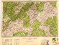
The Blue Ridge Mountains and Allegheny Mountains dominate this post-war landscape, providing a stark geographic divide between the valley settlements and the Piedmont plateau. Major urban centers at Roanoke and Lynchburg serve as the primary industrial hubs, connected by a dense network of transit that includes the Norfolk and Western Ry and the Virginian Ry. The map captures a moment when scenic infrastructure like the Blue Ridge Parkway and Skyline Drive were becoming established through the George Washington National Forest and Jefferson National Forest.
Find a feature on this map
148 named features on this map. Tap any name to fly to it.
Don’t see what you’re looking for? This feature index may not catch every label — zoom into the map to look around manually.
Map Details
Editions of this 1947 Roanoke Map
2 editions found

Other maps of this area

1887 · Spottsylvania
USGS Topo · 1:125,000

1887 · Lewisburg
USGS Topo · 1:125,000

1890 · Goochland
USGS Topo · 1:125,000

1890 · Roanoke
USGS Topo · 1:125,000

1890 · Christiansburg
USGS Topo · 1:125,000

1891 · Roanoke
USGS Topo · 1:125,000

1891 · Palmyra
USGS Topo · 1:125,000

1891 · Farmville
USGS Topo · 1:125,000

1891 · Lewisburg
USGS Topo · 1:125,000

1891 · Huntersville
USGS Topo · 1:125,000