1971 Map of Roanoke
USGS Topo · Published 1977About this map
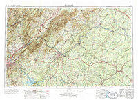
Covington sits at the western edge of this 1970s regional overview, which tracks the transportation and terrain patterns across central Virginia. The area serves as a significant mountain corridor where industrial rail lines and developing highway networks navigate the tight valleys of the Blue Ridge and Allegheny highlands. While many 1:250,000 sheets offer broad perspectives, this edition captures the era's infrastructure at a pivotal point, documenting the established settlement of Covington as it functioned as a regional hub for the surrounding mountain communities and resource-based industries during the latter half of the twentieth century.
Find a feature on this map
1 named feature on this map. Tap any name to fly to it.
Don’t see what you’re looking for? This feature index may not catch every label — zoom into the map to look around manually.
Map Details
Editions of this 1971 Roanoke Map
2 editions found

Other maps of this area

1887 · Spottsylvania
USGS Topo · 1:125,000

1887 · Lewisburg
USGS Topo · 1:125,000

1890 · Goochland
USGS Topo · 1:125,000

1890 · Roanoke
USGS Topo · 1:125,000

1890 · Christiansburg
USGS Topo · 1:125,000

1891 · Roanoke
USGS Topo · 1:125,000

1891 · Palmyra
USGS Topo · 1:125,000

1891 · Farmville
USGS Topo · 1:125,000

1891 · Lewisburg
USGS Topo · 1:125,000

1891 · Huntersville
USGS Topo · 1:125,000