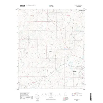
2018 Map of Roanoke West
USGS Topo · Published 2018About this map
Roanoke serves as the primary hub in this portion of Randolph County, where the street grid of the town center meets the rural expanses of eastern Alabama. The landscape is defined by the headwaters of the High Pine Creek and Cornhouse Cr systems, with small settlements like Broughton and Dickert scattered across the land-grant sections. Evidence of local community life is preserved through several rural burial grounds, including Union Hill Cem and Friendship Cem. To the north, distinctive landmarks such as White Signboard Crossroad and Harmon Crossroads mark traditional junctions in the county road network. The presence of Roanoke City Lake and McMurray Lake highlights the importance of water management for the surrounding area, while the Roanoke Municipal Airport indicates the modern infrastructure serving this historic Piedmont region.
Find a feature on this map
109 named features on this map. Tap any name to fly to it.
Don’t see what you’re looking for? This feature index may not catch every label — zoom into the map to look around manually.
Map Details
Editions of this 2018 Roanoke West Map
This is the sole edition of this map. No revisions or reprints were ever made.
Other maps of this area

1891 · Ashland
USGS Topo · 1:125,000

1899 · Wedowee
USGS Topo · 1:125,000

1902 · Wedowee
USGS Topo · 1:125,000

1953 · Atlanta
USGS Topo · 1:250,000

1957 · Atlanta
USGS Topo · 1:250,000

1958 · Atlanta
USGS Topo · 1:250,000
1968 · Five Points
USGS Topo · 1:24,000
1969 · Roanoke East
USGS Topo · 1:24,000

1969 · Wadley North
USGS Topo · 1:24,000
1969 · Napoleon
USGS Topo · 1:24,000