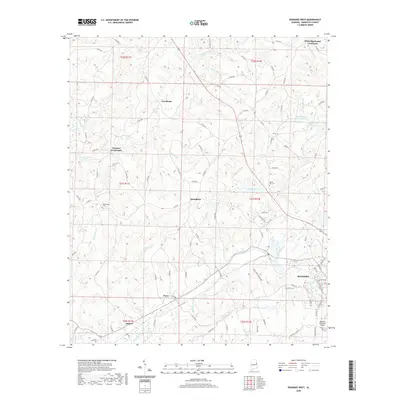
2020 Map of Roanoke West
USGS Topo · Published 2020About this map
The western outskirts of Roanoke anchor this 2020 landscape in Randolph County, where the transition from residential streets to rural farmstead patterns is clearly marked. The settlement geography is defined by local hubs like Broughton, Cornhouse, and the descriptive White Signboard Crossroad. These small communities are linked by an intricate network of county roads, such as Co Rd 333 and Louina Rd, which navigate the many creek branches feeding into High Pine Creek and Cornhouse Cr. Local history is preserved at sites like Friendship Cem and Union Hill Cem, while modern infrastructure is represented by the Roanoke Municipal Airport. The map captures a sophisticated view of the Piedmont terrain, illustrating how water bodies like Crystal Lake and McMurray Lake are integrated into the contemporary agricultural and residential footprint of the Alabama countryside.
Find a feature on this map
100 named features on this map. Tap any name to fly to it.
Don’t see what you’re looking for? This feature index may not catch every label — zoom into the map to look around manually.
Map Details
Editions of this 2020 Roanoke West Map
This is the sole edition of this map. No revisions or reprints were ever made.
Other maps of this area

1891 · Ashland
USGS Topo · 1:125,000

1899 · Wedowee
USGS Topo · 1:125,000

1902 · Wedowee
USGS Topo · 1:125,000

1953 · Atlanta
USGS Topo · 1:250,000

1957 · Atlanta
USGS Topo · 1:250,000

1958 · Atlanta
USGS Topo · 1:250,000
1968 · Five Points
USGS Topo · 1:24,000
1969 · Roanoke East
USGS Topo · 1:24,000

1969 · Wadley North
USGS Topo · 1:24,000
1969 · Napoleon
USGS Topo · 1:24,000