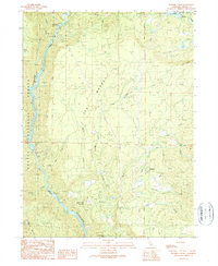
1990 Map of Roaring Creek
USGS Topo · Published 1990About this map
The Pit River corridor and its industrial development define this region of the Shasta National Forest during the late twentieth century. Hydroelectric infrastructure is prominent, including the James B Black Powerhouse, a Surge Chamber, and the Pit 6 Dam, which regulates the Pit River Reservoir. Amidst this engineered landscape, the Roaring Creek Rancheria and small settlements like Wengler and Richardson persist along the creek drainages. The map reveals the interplay between modern power generation and long-standing terrain features such as Flat Woods and The Cove. Genealogists may find interest in the scattered rural landmarks, including a Cem near Roaring Creek and the natural drop of Hatchet Creek Falls at the southern edge of the survey.
Find a feature on this map
42 named features on this map. Tap any name to fly to it.
Don’t see what you’re looking for? This feature index may not catch every label — zoom into the map to look around manually.
Map Details
Editions of this 1990 Roaring Creek Map
This is the sole edition of this map. No revisions or reprints were ever made.
Other maps of this area

1886 · Lassen Peak
USGS Topo · 1:250,000

1886 · Modoc Lava Bed
USGS Topo · 1:250,000

1886 · Shasta
USGS Topo · 1:250,000

1890 · Red Bluff
USGS Topo · 1:250,000

1892 · Modoc Lava-Bed
USGS Topo · 1:250,000

1892 · Lassen Peak
USGS Topo · 1:250,000

1894 · Lassen Peak
USGS Topo · 1:250,000

1894 · Red Bluff
USGS Topo · 1:250,000

1894 · Shasta
USGS Topo · 1:250,000

1901 · Redding
USGS Topo · 1:125,000