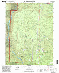
1998 Map of Roaring Creek
USGS Topo · Published 2003About this map
Hydropower infrastructure dominates this section of the Pit River canyon within the Shasta Trinity National Forests. Complex water management systems are visible along the river's bend, including the Pit Number 6 97-121 Dam, the Pit 5 Conduit Powerhouse, and an associated Substation. These engineering features reflect a landscape heavily modified for energy production, where the Pit River Reservoir meets the northern reaches of Shasta Lake.
Find a feature on this map
34 named features on this map. Tap any name to fly to it.
Don’t see what you’re looking for? This feature index may not catch every label — zoom into the map to look around manually.
Map Details
Editions of this 1998 Roaring Creek Map
This is the sole edition of this map. No revisions or reprints were ever made.
Other maps of this area

1886 · Lassen Peak
USGS Topo · 1:250,000

1886 · Modoc Lava Bed
USGS Topo · 1:250,000

1886 · Shasta
USGS Topo · 1:250,000

1890 · Red Bluff
USGS Topo · 1:250,000

1892 · Modoc Lava-Bed
USGS Topo · 1:250,000

1892 · Lassen Peak
USGS Topo · 1:250,000

1894 · Lassen Peak
USGS Topo · 1:250,000

1894 · Red Bluff
USGS Topo · 1:250,000

1894 · Shasta
USGS Topo · 1:250,000

1901 · Redding
USGS Topo · 1:125,000