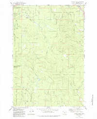
1979 Map of Roaring Creek
USGS Topo · Published 1984About this map
Tillamook State Forest dominates this landscape, covering a high-elevation divide where the headwaters of several major drainages diverge. The terrain is defined by prominent features such as Saddle Mtn and Baseline Ridge, which dictate the flow of the Devils Lake Fork Wilson River and the numerous tributaries like Roaring Creek and Scoggins Creek. During the 1970s, this area served primarily as timberland and recreation space, as evidenced by the presence of Rogers Forest Park and Camp Brown Forest Park. The transportation network is a mix of logging infrastructure and historic routes, including the Old Wilson River Road and the Stimson Mainline Road. Numerous unnamed Borrow Pits and a network of Jeep Trails suggest active forest management and resource extraction in this corner of the Coast Range.
Find a feature on this map
33 named features on this map. Tap any name to fly to it.
Don’t see what you’re looking for? This feature index may not catch every label — zoom into the map to look around manually.
Map Details
Editions of this 1979 Roaring Creek Map
2 editions found
Other maps of this area

1941 · Timber
USGS Topo · 1:62,500

1941 · Gales Creek
USGS Topo · 1:62,500

1941 · Yamhill
USGS Topo · 1:62,500

1942 · Yamhill
USGS Topo · 1:62,500

1942 · Fairdale
USGS Topo · 1:62,500

1948 · Vancouver
USGS Topo · 1:250,000

1950 · Vancouver
USGS Topo · 1:250,000

1950 · Vancouver
USGS Topo · 1:250,000

1955 · Timber
USGS Topo · 1:62,500

1955 · Fairdale
USGS Topo · 1:62,500