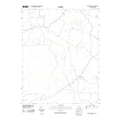
2010 Map of Roaring Spring
USGS Topo · Published 2010About this map
La Fayette serves as the central settlement in this portion of Christian County, situated near the intersection of the Old Clarksville Pike and Cheatham Rd. The landscape is defined by the winding course of Casey Creek to the west and the Little River at the northern boundary, reflecting a rural region where early transportation routes were often dictated by watercourses. A dense concentration of small family and community burial grounds, such as Dawson Cemetery, Simmons Cemetery, and Hester Cemetery, are scattered across the quadrangle, providing a critical geographic record for genealogical research. The southern portion of the map is marked by specialized infrastructure including Artillery Rd and W Perimeter Rd, indicating the proximity of military land use alongside traditional agricultural roads like Roaring Spring Rd.
Find a feature on this map
32 named features on this map. Tap any name to fly to it.
Don’t see what you’re looking for? This feature index may not catch every label — zoom into the map to look around manually.
Map Details
Editions of this 2010 Roaring Spring Map
This is the sole edition of this map. No revisions or reprints were ever made.
Other maps of this area

1950 · Caledonia
USGS Topo · 1:24,000

1951 · Church Hill
USGS Topo · 1:24,000

1951 · Caledonia
USGS Topo · 1:24,000

1951 · Roaring Spring
USGS Topo · 1:24,000

1951 · Johnson Hollow
USGS Topo · 1:24,000

1951 · Indian Mound
USGS Topo · 1:24,000

1951 · Bumpus Mills
USGS Topo · 1:24,000

1951 · Herndon
USGS Topo · 1:24,000

1951 · Woodlawn
USGS Topo · 1:24,000
1953 · Cadiz
USGS Topo · 1:24,000