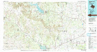
1986 Map of Robert Lee
USGS Topo · Published 1993About this map
The E V Spence Reservoir and the Colorado River dominate this West Texas landscape, illustrating the critical role of water management in the Concho Valley region during the mid-1980s. The map captures a transition from the elevated Divide and rugged peaks like Goat Mountain and Devil's Courthouse Peak to the agricultural plains near San Angelo. This era shows the established footprint of the Atchison Topeka and Santa Fe railroad as it connects small communities like Bronte, Miles, and Rowena. Significant petroleum activity is evident in the western reaches with an extensive Oil Field near Sterling City. Smaller, perhaps vanished localities such as Edith, Orient, and Shawville are documented alongside major landmarks like O C Fisher Lake, providing a clear view of the rural settlement patterns and industrial infrastructure of the time.
Find a feature on this map
100 named features on this map. Tap any name to fly to it.
Don’t see what you’re looking for? This feature index may not catch every label — zoom into the map to look around manually.
Map Details
Editions of this 1986 Robert Lee Map
2 editions found
Other maps of this area

1890 · Abilene
USGS Topo · 1:125,000

1891 · Hayrick
USGS Topo · 1:125,000

1892 · San Angelo
USGS Topo · 1:125,000

1892 · Eden
USGS Topo · 1:125,000

1892 · Abilene
USGS Topo · 1:125,000

1892 · Ballinger
USGS Topo · 1:125,000

1893 · Sweetwater
USGS Topo · 1:125,000

1894 · Hayrick
USGS Topo · 1:125,000

1895 · Sherwood
USGS Topo · 1:125,000

1896 · Eden
USGS Topo · 1:125,000