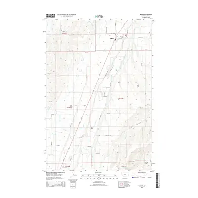
2014 Map of Roberts
USGS Topo · Published 2014About this map
The community of Roberts and the small settlement of Fox are the primary population centers on this landscape, which is defined by an intricate network of irrigation canals and natural waterways. This elaborate system of water management includes the Crockett Ditch, Tuck Crockett Ditch, and Taylor Ditch, which redirect water from sources like Rock Cr and Clear Cr to support the agricultural terraces of West Bench and East Bench. These features illustrate the vital role of engineering in the local ranching and farming economy of Carbon County.
Find a feature on this map
75 named features on this map. Tap any name to fly to it.
Don’t see what you’re looking for? This feature index may not catch every label — zoom into the map to look around manually.
Map Details
Editions of this 2014 Roberts Map
This is the sole edition of this map. No revisions or reprints were ever made.
Other maps of this area

1932 · Red Lodge No 2
USGS Topo · 1:48,000

1932 · Red Lodge No 1
USGS Topo · 1:48,000

1944 · Red Lodge
USGS Topo · 1:62,500

1954 · Billings
USGS Topo · 1:250,000

1956 · Roscoe NE
USGS Topo · 1:24,000

1956 · Roberts
USGS Topo · 1:24,000

1956 · Mount Maurice
USGS Topo · 1:62,500

1956 · Castagne
USGS Topo · 1:24,000
1956 · Boyd
USGS Topo · 1:24,000

1956 · The Big Slide
USGS Topo · 1:24,000