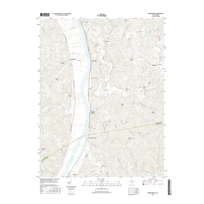
2016 Map of Robertsburg
USGS Topo · Published 2016About this map
The Kanawha River carves a deep valley through this Mason and Putnam County landscape, serving as the primary corridor for transportation and settlement between Leon and Buffalo. Along the eastern banks, the winding Charleston Rd connects riverfront hamlets like Arbuckle and Grimms Landing, while the interior hills are dotted with family-named landmarks and cemeteries including Riffle Chapel Cem and Manilla Cem. The geography is defined by a dense network of ridges and hollows, such as Wildcat Ridge and Boardman Hollow, which dictate the paths of numerous waterways like Thirteenmile Creek and Sixteenmile Creek. This map reveals a rural West Virginia community shaped by its hydrology, where small crossings like the Nat Truss Bridge and historically significant routes like Leon Ferry Ln facilitate movement through the dissected plateau.
Find a feature on this map
117 named features on this map. Tap any name to fly to it.
Don’t see what you’re looking for? This feature index may not catch every label — zoom into the map to look around manually.
Map Details
Editions of this 2016 Robertsburg Map
This is the sole edition of this map. No revisions or reprints were ever made.
Other maps of this area

1906 · Glenwood
USGS Topo · 1:62,500

1906 · Winfield
USGS Topo · 1:62,500

1908 · Glenwood
USGS Topo · 1:62,500

1908 · Winfield
USGS Topo · 1:62,500

1908 · Ravenswood
USGS Topo · 1:62,500

1908 · Point Pleasant
USGS Topo · 1:62,500

1926 · Ravenswood
USGS Topo · 1:62,500

1926 · Point Pleasant
USGS Topo · 1:62,500

1928 · Ravenswood
USGS Topo · 1:62,500

1929 · Point Pleasant
USGS Topo · 1:62,500