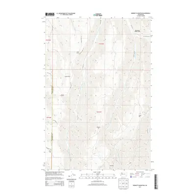
2013 Map of Robinette Mountain
USGS Topo · Published 2013About this map
The South Fork Touchet River carves a deep central artery through this portion of the Blue Mountains, defining the border between Walla Walla County and Columbia County. The landscape is dominated by high ridges and prominent peaks like Robinette Mtn and Jasper Mtn, which overlook a series of family-named drainages. These smaller canyons, including Payne Hollow, Hogeye Hollow, and Dustin Hollow, indicate a history of local land use and geographic naming tied to early inhabitants. In the northeast corner, Mountain Home Park and the Mountain Home Camp suggest a shift toward recreational use of the high timber, accessible via a network of ridgeline and valley roads such as S Touchet Rd and Jasper Mountain Rd. The convergence of the Wolf Fork and Robinson Fork further illustrates the complex drainage system feeding the Touchet watershed.
Find a feature on this map
25 named features on this map. Tap any name to fly to it.
Don’t see what you’re looking for? This feature index may not catch every label — zoom into the map to look around manually.
Map Details
Editions of this 2013 Robinette Mountain Map
This is the sole edition of this map. No revisions or reprints were ever made.
Other maps of this area

1919 · Walla Walla
USGS Topo · 1:125,000

1921 · Walla Walla
USGS Topo · 1:125,000

1937 · Pomeroy
USGS Topo · 1:96,000

1942 · Pomeroy
USGS Topo · 1:125,000

1953 · Walla Walla
USGS Topo · 1:250,000

1955 · Pullman
USGS Topo · 1:250,000

1958 · Pullman
USGS Topo · 1:250,000

1958 · Walla Walla
USGS Topo · 1:250,000
1966 · Coppei
USGS Topo · 1:24,000
1966 · Kooskooskie
USGS Topo · 1:24,000