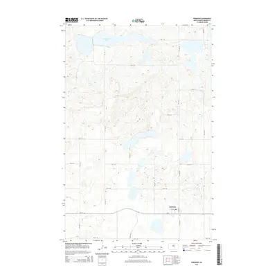
2014 Map of Robinson
USGS Topo · Published 2014About this map
Robinson serves as the primary hub of activity in this section of Kidder County, situated along the Nd-36 highway. The landscape is defined by the unique glaciated prairie potholes of North Dakota, with numerous small, unnamed sloughs and wetlands dotting the terrain surrounding Long Alakline Lake to the north. A centralized Po indicates the village's role as a local service point for the surrounding agricultural community. The map reveals a highly structured grid of section roads, including 17th St SE and 34th Ave SE, which partition the prairie into a network of farmstead access routes. This layout reflects the enduring influence of the Public Land Survey System on the settlement patterns and modern infrastructure of the Great Plains.
Find a feature on this map
20 named features on this map. Tap any name to fly to it.
Don’t see what you’re looking for? This feature index may not catch every label — zoom into the map to look around manually.
Map Details
Editions of this 2014 Robinson Map
This is the sole edition of this map. No revisions or reprints were ever made.
Other maps of this area

1952 · New Rockford
USGS Topo · 1:250,000

1956 · New Rockford
USGS Topo · 1:250,000

1971 · New Rockford
USGS Topo · 1:250,000

1972 · Tuttle
USGS Topo · 1:24,000

1972 · Kunkel Lake
USGS Topo · 1:24,000
1972 · Horsehead Lake
USGS Topo · 1:24,000

1972 · Robinson
USGS Topo · 1:24,000
1972 · Tuttle SW
USGS Topo · 1:24,000

1972 · Des Moines Lake
USGS Topo · 1:24,000

1978 · Wagon Wheel Hill
USGS Topo · 1:24,000