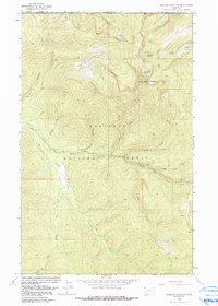
1963 Map of Robinson Mountain
USGS Topo · Published 1991About this map
Robinson Mountain stands as the central peak of this high-elevation landscape within the Kootenai National Forest, where the topography is defined by the sharp drainage basins of the Yaak River and its numerous tributaries. Just south of the international border with Canada, the area is characterized by alpine lakes such as Gold Lake, Lake Geneva, and Plumb Bob Lake tucked into glacial cirques. The 1963 field check reveals a terrain accessible primarily by a network of Pack Trails, with a specialized Lookout Sta positioned on the summit of Robinson Mountain for fire surveillance. The intricate drainage network, including Sink Creek and Caribou Creek, underscores the remote wilderness character of this portion of Lincoln County before modern road development penetrated the deeper reaches of the forest.
Find a feature on this map
28 named features on this map. Tap any name to fly to it.
Don’t see what you’re looking for? This feature index may not catch every label — zoom into the map to look around manually.
Map Details
Editions of this 1963 Robinson Mountain Map
2 editions found
Other maps of this area

1957 · Kalispell
USGS Topo · 1:250,000

1960 · Kalispell
USGS Topo · 1:250,000

1961 · Kalispell
USGS Topo · 1:250,000

1963 · Robinson Mountain
USGS Topo · 1:24,000

1963 · Red Mountain
USGS Topo · 1:24,000

1963 · Webb Mountain
USGS Topo · 1:24,000

1963 · Boulder Lakes
USGS Topo · 1:24,000

1963 · Mount Henry
USGS Topo · 1:24,000

1963 · Lost Horse Mountain
USGS Topo · 1:24,000

1979 · Yaak River
USGS Topo · 1:100,000