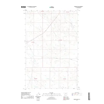
2020 Map of Robinson School
USGS Topo · Published 2020About this map
Robinson School serves as a lone landmark in this high plains landscape of Phillips County, where the topography is defined by the drainages of Alder Cr and Camp Cr. The transition from the northern reaches of t25n r25e to the southern townships reveals a series of critical water management features, most notably Big Sage Reservoir and Seven-Up Reservoir. These catchments, along with named waterways like Beauchamp Cr and C K Cr, suggest a land primarily organized around livestock and ranching needs. The road network is sparse, centered on the corridor of 191 and secondary routes like Dry Fork Rd, reflecting the expansive, low-density character of this portion of north-central Montana.
Find a feature on this map
17 named features on this map. Tap any name to fly to it.
Don’t see what you’re looking for? This feature index may not catch every label — zoom into the map to look around manually.
Map Details
Editions of this 2020 Robinson School Map
This is the sole edition of this map. No revisions or reprints were ever made.
Other maps of this area

1943 · Landusky
USGS Topo · 1:125,000

1954 · Bell Ridge East
USGS Topo · 1:24,000

1954 · Lewistown
USGS Topo · 1:250,000

1959 · Lewistown
USGS Topo · 1:250,000

1971 · Bear Mountain
USGS Topo · 1:24,000

1971 · Robinson School
USGS Topo · 1:24,000

1971 · Hays SE
USGS Topo · 1:24,000

1971 · Bison Bone Reservoir
USGS Topo · 1:24,000
1971 · Zortman
USGS Topo · 1:24,000
1971 · Coburn Butte
USGS Topo · 1:24,000