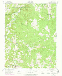
1954 Map of Roby
USGS Topo · Published 1977About this map
Roubidoux Creek carves a winding path through this portion of the Ozark Highlands, where the northern boundary of the Mark Twain National Forest meets the southern edge of the Fort Leonard Wood Military Reservation. The map captures a transitional rural landscape in the mid-1950s, characterized by dispersed settlements like Roby, Plato, and Evening Shade. Topographic details reveal the limestone geology of the region, specifically noted at Daniels Sinkhole, while ridges such as Salt Ridge and Rock Ridge define the local elevation.
Find a feature on this map
26 named features on this map. Tap any name to fly to it.
Don’t see what you’re looking for? This feature index may not catch every label — zoom into the map to look around manually.
Map Details
Editions of this 1954 Roby Map
3 editions found
Other maps of this area

1931 · Manes
USGS Topo · 1:48,000

1941 · Big Piney
USGS Topo · 1:62,500

1941 · Manes
USGS Topo · 1:62,500

1941 · Bado
USGS Topo · 1:62,500

1943 · Big Piney
USGS Topo · 1:62,500

1943 · Manes
USGS Topo · 1:62,500

1943 · Drynob
USGS Topo · 1:62,500

1943 · Bado
USGS Topo · 1:62,500

1954 · Springfield
USGS Topo · 1:250,000

1954 · Drynob
USGS Topo · 1:62,500