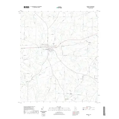
2020 Map of Rochelle
USGS Topo · Published 2020About this map
Rochelle serves as the central hub for this Wilcox County landscape, where the street grid of 1st Ave and Gordon St meets the outlying agricultural fields. The area is dense with small, family-named and community cemeteries that speak to the deep genealogical roots of the region, including Evergreen Cem and Morningside Cem near the town center, and the more isolated Walker Cem and Hannah Cem further south. The hydrology is defined by the winding course of Mill Creek and Reynolds Creek, both feeding toward the Alapaha River in the southwest corner. Further east, the small settlement of Owensboro is anchored by the Pleasant Grove Baptist Church Cem, illustrating how rural Georgia communities organized around church and burial sites. This map captures the intersection of traditional land use and the modern road network, from Cantrell Rd to the more distant Kramer crossroads.
Find a feature on this map
111 named features on this map. Tap any name to fly to it.
Don’t see what you’re looking for? This feature index may not catch every label — zoom into the map to look around manually.
Map Details
Editions of this 2020 Rochelle Map
This is the sole edition of this map. No revisions or reprints were ever made.
Other maps of this area

1953 · Waycross
USGS Topo · 1:250,000

1957 · Macon
USGS Topo · 1:250,000

1958 · Macon
USGS Topo · 1:250,000

1958 · Waycross
USGS Topo · 1:250,000

1964 · Macon
USGS Topo · 1:250,000

1971 · Pineview West
USGS Topo · 1:24,000

1972 · Abbeville North
USGS Topo · 1:24,000

1972 · Pineview East
USGS Topo · 1:24,000

1974 · Rebecca
USGS Topo · 1:24,000
1974 · Abbeville South
USGS Topo · 1:24,000