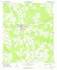
1977 Map of Rochelle
USGS Topo · Published 1977About this map
The railroad town of Rochelle serves as the focal point of this 1970s Wilcox County landscape, situated at the junction of several regional routes. The active Seaboard Coast Line runs east-west through the center of town, while an Old Railroad Grade follows the path of Reynolds Creek to the northwest, illustrating the evolution of local transit. This area is characterized by its agricultural character, evidenced by numerous fence and field lines recorded from aerial photography.
Find a feature on this map
25 named features on this map. Tap any name to fly to it.
Don’t see what you’re looking for? This feature index may not catch every label — zoom into the map to look around manually.
Map Details
Editions of this 1977 Rochelle Map
This is the sole edition of this map. No revisions or reprints were ever made.
Other maps of this area

1953 · Waycross
USGS Topo · 1:250,000

1957 · Macon
USGS Topo · 1:250,000

1958 · Macon
USGS Topo · 1:250,000

1958 · Waycross
USGS Topo · 1:250,000

1964 · Macon
USGS Topo · 1:250,000

1971 · Pineview West
USGS Topo · 1:24,000

1972 · Abbeville North
USGS Topo · 1:24,000

1972 · Pineview East
USGS Topo · 1:24,000

1974 · Rebecca
USGS Topo · 1:24,000
1974 · Abbeville South
USGS Topo · 1:24,000