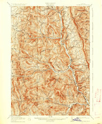
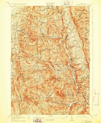
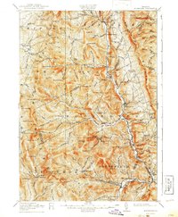
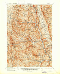
1917 Map of Rochester
USGS Topo · Published 1936About this map
White River valley settlements define the orientation of this mountain landscape during the early twentieth century. This survey, conducted by R.B. Marshall and Frank Sutton, documents a time when the rural economy centered on small, dispersed hubs such as Rochester and Hancock. The map reveals a high concentration of district schools, including Stony Mill School, Texas School, and Jerusalem School, reflecting a time before school consolidation when local education was decentralized across the valleys. Resource extraction and forestry are evident through the presence of the Williams Mine and various camps such as Bingo Camp and Michigan Camp. The high peaks of the Green Mountains create a natural barrier, with critical passage limited to narrow points like Middlebury Gap and Brandon Gap, while the Tweed River and Hancock Branch dictate the path of early roads through the granite terrain.
Find a feature on this map
134 named features on this map. Tap any name to fly to it.
Don’t see what you’re looking for? This feature index may not catch every label — zoom into the map to look around manually.
Map Details
Editions of this 1917 Rochester Map
5 editions found

Other maps of this area

1891 · Rutland
USGS Topo · 1:62,500

1893 · Rutland
USGS Topo · 1:62,500

1895 · Castleton
USGS Topo · 1:62,500

1897 · Castleton
USGS Topo · 1:62,500

1902 · Brandon
USGS Topo · 1:62,500

1903 · Middlebury
USGS Topo · 1:62,500

1904 · Brandon
USGS Topo · 1:62,500

1905 · Middlebury
USGS Topo · 1:62,500

1911 · Woodstock
USGS Topo · 1:62,500

1913 · Woodstock
USGS Topo · 1:62,500