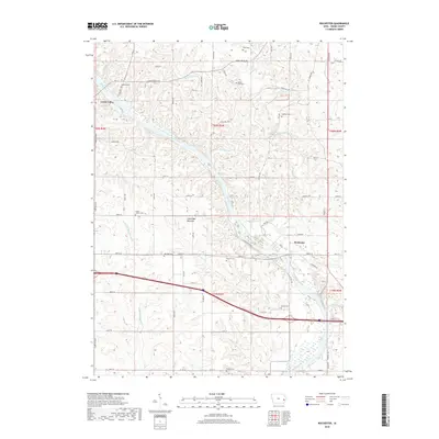
2018 Map of Rochester
USGS Topo · Published 2018About this map
Cedar River dominates the center of this 2018 survey, carving a wide path through Cedar County where the Green Bay Bottoms mark its low-lying floodplain. The settlement of Rochester sits on the eastern bank, while Cedar Valley is positioned to the northwest, connected by a network of rural roads such as Stone Mill Rd and W Rochester Ave. The landscape is a mix of agricultural plots and dense creek systems, including Rock Creek and Pee Dee Cr, which feed into the main river channel.
Find a feature on this map
45 named features on this map. Tap any name to fly to it.
Don’t see what you’re looking for? This feature index may not catch every label — zoom into the map to look around manually.
Map Details
Editions of this 2018 Rochester Map
This is the sole edition of this map. No revisions or reprints were ever made.
Other maps of this area

1889 · Tipton
USGS Topo · 1:62,500

1890 · Tipton
USGS Topo · 1:62,500

1891 · Mechanicsville
USGS Topo · 1:62,500

1891 · Wilton Junction
USGS Topo · 1:62,500

1894 · Mechanicsville
USGS Topo · 1:62,500

1894 · West Liberty
USGS Topo · 1:62,500

1901 · Stanwood
USGS Topo · 1:125,000

1953 · Wilton Junction
USGS Topo · 1:24,000
1953 · Tipton East
USGS Topo · 1:24,000
1953 · Lime City
USGS Topo · 1:24,000