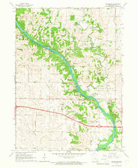
1965 Map of Rochester
USGS Topo · Published 1967About this map
The Cedar River carves a deep, wooded path through the heart of Cedar County, anchoring the settlement of Rochester and the smaller community at Cedar Valley. This mid-1960s survey reveals a landscape where the river was the central geographic focus, before the full modernization of the regional highway system. The terrain is notably dissected by a network of drainage systems including Rock Creek, Rock Run, and the winding Pee Dee Creek, which give rise to numerous small hollows and ridges. Rural life is anchored by family and community heritage, evidenced by several scattered burial grounds such as Pee Dee Cem, Mt Zion Cem, and the river-adjacent Rochester Cem. The presence of several Quarry sites and a Sandpit along the riverbank indicates a local economy tied to the extraction of natural resources from the river valley and its limestone-rich bluffs.
Find a feature on this map
25 named features on this map. Tap any name to fly to it.
Don’t see what you’re looking for? This feature index may not catch every label — zoom into the map to look around manually.
Map Details
Editions of this 1965 Rochester Map
This is the sole edition of this map. No revisions or reprints were ever made.
Other maps of this area

1889 · Tipton
USGS Topo · 1:62,500

1890 · Tipton
USGS Topo · 1:62,500

1891 · Mechanicsville
USGS Topo · 1:62,500

1891 · Wilton Junction
USGS Topo · 1:62,500

1894 · Mechanicsville
USGS Topo · 1:62,500

1894 · West Liberty
USGS Topo · 1:62,500

1901 · Stanwood
USGS Topo · 1:125,000

1953 · Wilton Junction
USGS Topo · 1:24,000
1953 · Tipton East
USGS Topo · 1:24,000
1953 · Lime City
USGS Topo · 1:24,000