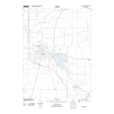
2010 Map of Rochester
USGS Topo · Published 2010About this map
Lake Manitou dominates the eastern landscape of Rochester, featuring several named landforms including Big Island, Treasure Island, and Coney Island. This area in Fulton County is defined by its complex water management system, where the Tippecanoe River and Mill Creek are supplemented by an extensive network of drainage features like Minnow Ditch and McMahan Ditch. Genealogy researchers will find several significant burial sites, such as the Independent Order of Odd Fellows Cemetery and Citizens Cemetery near the city center, as well as the more remote Old Shelton Cemetery to the south.
Find a feature on this map
78 named features on this map. Tap any name to fly to it.
Don’t see what you’re looking for? This feature index may not catch every label — zoom into the map to look around manually.
Map Details
Editions of this 2010 Rochester Map
This is the sole edition of this map. No revisions or reprints were ever made.
Other maps of this area

1953 · Chicago
USGS Topo · 1:250,000

1953 · Danville
USGS Topo · 1:250,000

1955 · Danville
USGS Topo · 1:250,000

1956 · Danville
USGS Topo · 1:250,000

1957 · Chicago
USGS Topo · 1:250,000

1959 · Mentone
USGS Topo · 1:24,000

1960 · Fulton
USGS Topo · 1:24,000

1960 · Macy
USGS Topo · 1:24,000
1960 · Deedsville
USGS Topo · 1:24,000

1962 · Pershing
USGS Topo · 1:24,000