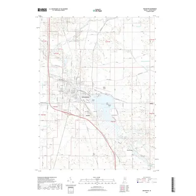
2019 Map of Rochester
USGS Topo · Published 2019About this map
Rochester serves as a central hub in north-central Indiana, defined by its relationship with the expansive Lake Manitou and the winding Tippecanoe River to the north. This modern topographic record illustrates a landscape deeply shaped by agricultural drainage, marked by an extensive network of named waterways like McMahan Ditch, Blair Ditch, and Whittenberger Eiler Ditch that crisscross the surrounding farmland. These ditches reveal the long-term engineering effort required to manage the wetlands and low-lying areas of Fulton County for cultivation.
Find a feature on this map
108 named features on this map. Tap any name to fly to it.
Don’t see what you’re looking for? This feature index may not catch every label — zoom into the map to look around manually.
Map Details
Editions of this 2019 Rochester Map
This is the sole edition of this map. No revisions or reprints were ever made.
Other maps of this area

1953 · Chicago
USGS Topo · 1:250,000

1953 · Danville
USGS Topo · 1:250,000

1955 · Danville
USGS Topo · 1:250,000

1956 · Danville
USGS Topo · 1:250,000

1957 · Chicago
USGS Topo · 1:250,000

1959 · Mentone
USGS Topo · 1:24,000

1960 · Fulton
USGS Topo · 1:24,000

1960 · Macy
USGS Topo · 1:24,000
1960 · Deedsville
USGS Topo · 1:24,000

1962 · Pershing
USGS Topo · 1:24,000