
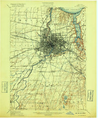
1912 Map of Rochester
USGS Topo · Published 1912About this map
The Genesee River serves as the central artery for this 1912 survey, cutting through the dense urban core of Rochester before reaching Lake Ontario at Charlotte. The landscape is a complex intersection of early 20th-century transportation, featuring the historic Erie Canal and the newly appearing Barge Canal under construction. To the south, the Genesee Valley Canal (Abandoned) traces a vanished route through Chili and Wheatland, illustrating the rapid evolution of New York's waterway infrastructure.
Find a feature on this map
83 named features on this map. Tap any name to fly to it.
Don’t see what you’re looking for? This feature index may not catch every label — zoom into the map to look around manually.
Map Details
Editions of this 1912 Rochester Map
2 editions found
Other maps of this area

1895 · Rochester
USGS Topo · 1:62,500

1895 · Ontario Beach
USGS Topo · 1:62,500

1898 · Rochester
USGS Topo · 1:62,500

1899 · Hamlin
USGS Topo · 1:62,500

1899 · Ontario Beach
USGS Topo · 1:62,500

1899 · Brockport
USGS Topo · 1:62,500

1900 · Macedon
USGS Topo · 1:62,500

1900 · Canandaigua
USGS Topo · 1:62,500

1901 · Honeoye
USGS Topo · 1:62,500

1903 · Canandaigua
USGS Topo · 1:62,500