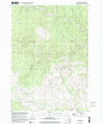
1998 Map of Rochford
USGS Topo · Published 2001About this map
Black Hills timber and mining terrain dominate this late 20th-century survey of Pennington County. The settlement of Rochford serves as a focal point, situated near the Standby Mine and the Rochford Cem. The landscape is deeply incised by a dense network of gulches and creeks, including Moonshine Gulch, Bearcat Gulch, and Rapid Creek, which define the region's rugged geography.
Find a feature on this map
42 named features on this map. Tap any name to fly to it.
Don’t see what you’re looking for? This feature index may not catch every label — zoom into the map to look around manually.
Map Details
Editions of this 1998 Rochford Map
This is the sole edition of this map. No revisions or reprints were ever made.
Other maps of this area

1894 · Deadwood
USGS Topo · 1:125,000

1896 · Harney Peak
USGS Topo · 1:125,000

1901 · Harney Peak
USGS Topo · 1:125,000

1901 · Deadwood
USGS Topo · 1:125,000

1916 · Deadwood
USGS Topo · 1:125,000

1953 · Nemo
USGS Topo · 1:24,000

1953 · Rapid City
USGS Topo · 1:250,000

1954 · Silver City
USGS Topo · 1:24,000

1954 · Hill City
USGS Topo · 1:24,000

1955 · Hot Springs
USGS Topo · 1:250,000