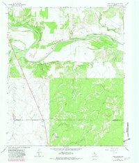
1966 Map of Rock Canyon
USGS Topo · Published 1982About this map
The Brazos River carves a significant course through this North Texas landscape, defining the topography with the prominent Horseshoe Bend in the northwest. This mid-1960s survey, updated with late-1970s aerial data, reveals a transition between the ranching and resource-extraction economies at the border of Baylor and Throckmorton counties. The terrain is marked by numerous drainage systems, including Turkey Creek, Deep Creek, and the namesake Rock Canyon. To the south, Twin Mountain serves as a distinct landmark near the headwaters of Wagon Creek. Evidence of local industry is sparse but present, shown through scattered Oil Wells and several Gravel Pits along the river banks. Surveyed just before significant modern developments, the map preserves the original drainage patterns of Horse Creek and Miller Creek and records the locations of agricultural Storage Bins used during this era.
Find a feature on this map
19 named features on this map. Tap any name to fly to it.
Don’t see what you’re looking for? This feature index may not catch every label — zoom into the map to look around manually.
Map Details
Editions of this 1966 Rock Canyon Map
2 editions found
Other maps of this area

1954 · Wichita Falls
USGS Topo · 1:250,000

1958 · Wichita Falls
USGS Topo · 1:250,000

1962 · Antelope Creek SE
USGS Topo · 1:24,000

1962 · Antelope Creek NE
USGS Topo · 1:24,000

1966 · Seymour West
USGS Topo · 1:24,000

1966 · Westover SE
USGS Topo · 1:24,000

1966 · Rock Canyon
USGS Topo · 1:24,000

1966 · Westover SW
USGS Topo · 1:24,000

1966 · Seymour East
USGS Topo · 1:24,000
1966 · Cope Branch
USGS Topo · 1:24,000