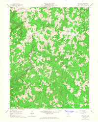
1966 Map of Rock Cave
USGS Topo · Published 1967About this map
The French Creek Game Farm serves as a prominent landmark in this mid-1960s survey of Upshur County, situated within a landscape defined by the winding Little Kanawha River and Little Kanawha Mountain. The geography is characterized by narrow ridges such as Mulberry Ridge and Heaston Ridge, where small communities like Rock Cave and Arlington are connected by a network of rural roads and river valleys. The economy of the era is evidenced by a Baltimore and Ohio railroad line in the northwest and various infrastructure including a Compressor Sta and several Pipelines.
Find a feature on this map
67 named features on this map. Tap any name to fly to it.
Don’t see what you’re looking for? This feature index may not catch every label — zoom into the map to look around manually.
Map Details
Editions of this 1966 Rock Cave Map
This is the sole edition of this map. No revisions or reprints were ever made.
Other maps of this area

1893 · Buckhannon
USGS Topo · 1:125,000

1896 · Buckhannon
USGS Topo · 1:125,000

1897 · Buckhannon
USGS Topo · 1:125,000

1912 · Sago
USGS Topo · 1:48,000

1912 · Crawford
USGS Topo · 1:48,000

1913 · Hacker Valley
USGS Topo · 1:48,000

1913 · Pickens
USGS Topo · 1:48,000

1914 · Sago
USGS Topo · 1:62,500

1914 · Crawford
USGS Topo · 1:62,500

1915 · Hacker Valley
USGS Topo · 1:62,500