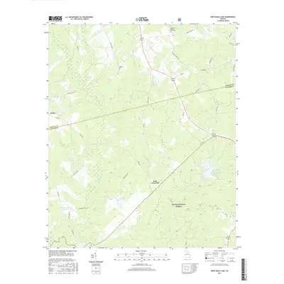
2017 Map of Rock Eagle Lake
USGS Topo · Published 2017About this map
The rolling Piedmont landscape of Putnam and Morgan Counties is defined here by the headwaters of the Little River and the sprawling woodlands of the Oconee National Forest. This 2017 survey details a rural region where agriculture and managed forest lands meet, centered on the historic community of Godfrey and the intersection at Reids Crossroads. Water management is a visible priority across the terrain, evidenced by numerous man-made bodies including Rock Eagle Lake, Georgia Experiment Station Lake, and Experiment Lake Number One. For genealogists and local historians, the map preserves the locations of several important family and community landmarks, such as the Springfield Baptist Church Cem and the Shepherd Cem. The land is bisected by numerous rural routes like Seven Islands Rd and Bethany Church Rd, tracing the drainage patterns of Glady Cr and Big Indian Cr.
Find a feature on this map
43 named features on this map. Tap any name to fly to it.
Don’t see what you’re looking for? This feature index may not catch every label — zoom into the map to look around manually.
Map Details
Editions of this 2017 Rock Eagle Lake Map
This is the sole edition of this map. No revisions or reprints were ever made.
Other maps of this area

1896 · Monroe
USGS Topo · 1:125,000

1953 · Athens
USGS Topo · 1:250,000

1958 · Athens
USGS Topo · 1:250,000

1959 · Athens
USGS Topo · 1:250,000

1963 · Athens
USGS Topo · 1:250,000

1972 · Meda
USGS Topo · 1:24,000

1972 · Eatonton
USGS Topo · 1:24,000

1972 · Buckhead
USGS Topo · 1:24,000

1972 · Shady Dale
USGS Topo · 1:24,000
1972 · Smithboro
USGS Topo · 1:24,000