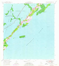
1947 Map of Rock Harbor
USGS Topo · Published 1976About this map
Key Largo serves as the central spine of this coastal survey, where the developing Florida Keys landscape is captured during a period of significant growth. The map illustrates the specialized water-dependent geography of the region, anchored by the Intracoastal Waterway slicing through Buttonwood Sound and providing a protected route inside the reef. Established communities like Rock Harbor and Newport are visible along the main transit corridor, supported by local landmarks such as St Margarets Ch and Getman Memorial Ch. To the west, the boundary of Everglades National Park encompasses the intricate island chains of the Swash Keys and Shell Key. The eastern shoreline transitions into the Atlantic Ocean, marked by distinctive features like El Radabob and the offshore Rodriguez Key. This 1947 base, with 1969 photorevisions, highlights the shift from a maritime-dependent island chain to an increasingly residential and recreational destination.
Find a feature on this map
42 named features on this map. Tap any name to fly to it.
Don’t see what you’re looking for? This feature index may not catch every label — zoom into the map to look around manually.
Map Details
Editions of this 1947 Rock Harbor Map
4 editions found
Other maps of this area

1947 · Garden Cove
USGS Topo · 1:24,000

1947 · Rock Harbor
USGS Topo · 1:24,000

1947 · Blackwater Sound
USGS Topo · 1:24,000

1949 · Blackwater Sound
USGS Topo · 1:24,000

1949 · Rock Harbor
USGS Topo · 1:24,000

1949 · Garden Cove
USGS Topo · 1:24,000

1956 · Miami
USGS Topo · 1:250,000

1958 · Miami
USGS Topo · 1:250,000

1971 · Tavernier
USGS Topo · 1:24,000

1971 · Plantation Key
USGS Topo · 1:24,000