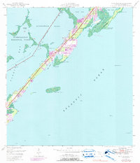
1947 Map of Rock Harbor
USGS Topo · Published 1991About this map
Key Largo's narrow profile dominates this mid-century coastal survey, capturing the island during a period of rapid residential expansion as shown by extensive street grids and canal developments. The settlement of Rock Harbor serves as a central point of activity, flanked by smaller hamlets like Newport, Thompson, and Sawyer. Religious life is anchored by St Margarets Ch and Getman Memorial Ch, providing clear landmarks for local genealogical research. The geography is defined by the contrast between the protected waters of Buttonwood Sound and the open Atlantic Ocean. To the northwest, the boundary of Everglades National Park encompasses the Swash Keys and Florida Bay, while the Intracoastal Waterway cuts a straight line through the flats, marked by a series of beacons and lights to guide maritime traffic through Baker Cut.
Find a feature on this map
42 named features on this map. Tap any name to fly to it.
Don’t see what you’re looking for? This feature index may not catch every label — zoom into the map to look around manually.
Map Details
Editions of this 1947 Rock Harbor Map
4 editions found
Other maps of this area

1947 · Garden Cove
USGS Topo · 1:24,000

1947 · Rock Harbor
USGS Topo · 1:24,000

1947 · Blackwater Sound
USGS Topo · 1:24,000

1949 · Blackwater Sound
USGS Topo · 1:24,000

1949 · Rock Harbor
USGS Topo · 1:24,000

1949 · Garden Cove
USGS Topo · 1:24,000

1956 · Miami
USGS Topo · 1:250,000

1958 · Miami
USGS Topo · 1:250,000

1971 · Tavernier
USGS Topo · 1:24,000

1971 · Plantation Key
USGS Topo · 1:24,000