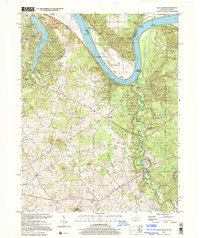
1998 Map of Rock Haven
USGS Topo · Published 2001About this map
Ohio River landings and industrial legacy define this stretch of the border between Kentucky and Indiana. The landscape is shaped by the subterranean activity of the Doe Run Gas Storage Field and the surface utility of Doe Run Mill. Settlement patterns follow the winding course of the river and the fertile basins of Otter Creek, where community life is anchored by locations like Grahamton, Lickskillet, and the Otter Creek Park.
Find a feature on this map
51 named features on this map. Tap any name to fly to it.
Don’t see what you’re looking for? This feature index may not catch every label — zoom into the map to look around manually.
Map Details
Editions of this 1998 Rock Haven Map
This is the sole edition of this map. No revisions or reprints were ever made.
Other maps of this area

1909 · Kosmosdale
USGS Topo · 1:48,000

1912 · Kosmosdale
USGS Topo · 1:62,500

1931 · Corydon
USGS Topo · 1:62,500

1936 · Vine Grove
USGS Topo · 1:62,500

1941 · Ekron
USGS Topo · 1:62,500

1943 · Vine Grove
USGS Topo · 1:62,500

1946 · Rock Haven
USGS Topo · 1:24,000

1946 · Fort Knox
USGS Topo · 1:24,000

1946 · Vine Grove
USGS Topo · 1:24,000

1946 · Vine Grove
USGS Topo · 1:62,500