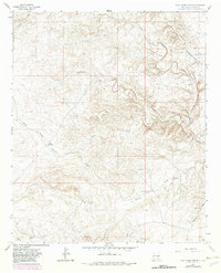
1962 Map of Rock House Canyon
USGS Topo · Published 1982About this map
Arroyo del Macho and the winding Rock House Canyon define this section of the Chaves County high desert, where water management was central to survival and ranching in the early 1960s. The landscape is dotted with critical water sources, including catchment basins like China Tank and Gavi Tank, and subterranean access points such as North Well and South Well. These features support localized ranching operations, most notably the Macho Ranch and the Irwin Corn Ranch, as well as the small settlement at Eddleman. The map illustrates a complex network of draws, such as China Draw and Bajillo Draw, which channel seasonal runoff through the arid terrain. For those tracing the history of New Mexico ranching or the development of water infrastructure in the Pecos River basin, this survey documents the exact placement of tanks, wells, and fence lines during a period of active land use before later twentieth-century shifts.
Find a feature on this map
18 named features on this map. Tap any name to fly to it.
Don’t see what you’re looking for? This feature index may not catch every label — zoom into the map to look around manually.
Map Details
Editions of this 1962 Rock House Canyon Map
2 editions found
Other maps of this area

1955 · Roswell
USGS Topo · 1:250,000

1958 · Roswell
USGS Topo · 1:250,000

1962 · Roswell
USGS Topo · 1:250,000

1962 · Rock House Canyon
USGS Topo · 1:24,000

1962 · Panther Hill
USGS Topo · 1:24,000

1962 · Marley Draw
USGS Topo · 1:24,000
1963 · Barn Draw
USGS Topo · 1:24,000

1967 · Round Mountain SE
USGS Topo · 1:24,000
1967 · White Flat SE
USGS Topo · 1:24,000
1967 · Mesa SE
USGS Topo · 1:24,000