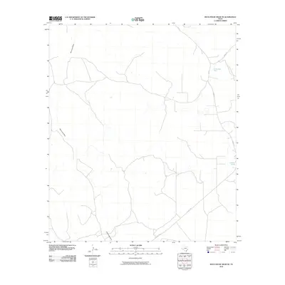
2010 Map of Rock House Draw NE
USGS Topo · Published 2010About this map
Rock House Draw and Monument Draw anchor this West Texas landscape in Pecos County, where the topography is defined by seasonal watercourses and specialized drainage. These ephemeral features are joined by industrial and agricultural water management sites like Little Bull Tank and the uniquely named Cisposal Pond. The area is networked by a series of transit routes that speak to the ranching and energy operations common to the Permian Basin, including FM 2023 and local arteries such as Harral Rd and Puckett Rd. The map illustrates the spatial relationship between wide-open ranch land and the infrastructure required to sustain it in an arid environment, providing a clear record of land use and water resources in the early twenty-first century.
Find a feature on this map
7 named features on this map. Tap any name to fly to it.
Don’t see what you’re looking for? This feature index may not catch every label — zoom into the map to look around manually.
Map Details
Editions of this 2010 Rock House Draw NE Map
This is the sole edition of this map. No revisions or reprints were ever made.
Other maps of this area

1928 · Comanche Spring
USGS Topo · 1:125,000

1929 · Independence Draw Quadrangle
USGS Topo · 1:125,000

1954 · Fort Stockton
USGS Topo · 1:250,000

1958 · Fort Stockton
USGS Topo · 1:250,000

1969 · Skyscraper Peak
USGS Topo · 1:24,000

1969 · Hackberry Draw NW
USGS Topo · 1:24,000
1969 · Hackberry Draw SW
USGS Topo · 1:24,000
1970 · Panther Bluff
USGS Topo · 1:24,000
1970 · East Mesa SW
USGS Topo · 1:24,000

1973 · Fort Stockton
USGS Topo · 1:250,000