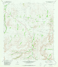
1980 Map of Rock House Draw
USGS Topo · Published 1980About this map
Independence Creek winds through the southern reaches of this Pecos County landscape, providing a rare riparian corridor in an otherwise arid drainage system. During the early 1980s, this area was defined by its resource extraction and logistical infrastructure, evidenced by numerous Gravel Pits, Wells, and Drill Holes scattered across the terrain. The central topographical feature, Rock House Draw, cuts diagonally across the quadrangle, serving as a primary watershed for the surrounding hills. Human activity is marked by industrial utility, including a prominent Pipeline and a Landing Strip situated between the draws. Remote landmarks like the Water Tank and various nameless tanks suggest a landscape primarily managed for ranching and energy exploration during this period of West Texas development.
Find a feature on this map
14 named features on this map. Tap any name to fly to it.
Don’t see what you’re looking for? This feature index may not catch every label — zoom into the map to look around manually.
Map Details
Editions of this 1980 Rock House Draw Map
This is the sole edition of this map. No revisions or reprints were ever made.
Other maps of this area

1920 · Longfellow
USGS Topo · 1:125,000

1928 · Sanderson
USGS Topo · 1:125,000

1928 · Comanche Spring
USGS Topo · 1:125,000

1929 · Independence Draw Quadrangle
USGS Topo · 1:125,000

1954 · Fort Stockton
USGS Topo · 1:250,000

1958 · Fort Stockton
USGS Topo · 1:250,000

1968 · Busher Canyon
USGS Topo · 1:24,000

1968 · Ebers Camp
USGS Topo · 1:24,000

1969 · Big Canyon Ranch NW
USGS Topo · 1:24,000

1969 · Hackberry Draw NW
USGS Topo · 1:24,000