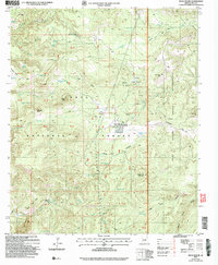
2004 Map of Rock House
USGS Topo · Published 2006About this map
Rock House sits at the center of this high-desert landscape, serving as a rare focal point in a territory defined by complex topography and water scarcity. Situated within the Tonto National Forest and bordering the Fort Apache Indian Reservation, the area is marked by a network of ranching and mining infrastructure. Cattle tanks such as Pendleton Tank, Castle Butte Tank, and Middle Pasture Tank are distributed across the drainage basins of Sloan Creek and Forks Creek, indicating the continued importance of livestock management in Gila County. Landmark elevations like Castle Peak, Gunsight Butte, and Brushy Top Mountain dominate the horizon, while numerous prospects and Adits scattered near Rock Creek and Horse Canyon hint at the region's mineral exploration history. The presence of the Horse Camp Windmill and various corrals underscores a landscape transition where traditional high-country ranching meets the steep ridges of Hobble Mesa and Keystone Ridge.
Find a feature on this map
66 named features on this map. Tap any name to fly to it.
Don’t see what you’re looking for? This feature index may not catch every label — zoom into the map to look around manually.
Map Details
Editions of this 2004 Rock House Map
This is the sole edition of this map. No revisions or reprints were ever made.
Other maps of this area

1886 · Holbrook
USGS Topo · 1:250,000

1893 · Holbrook
USGS Topo · 1:250,000

1922 · Chrysotile
USGS Topo · 1:125,000

1946 · Blue House Mtn
USGS Topo · 1:62,500

1949 · McFadden Peak
USGS Topo · 1:62,500

1950 · McFadden Peak
USGS Topo · 1:62,500

1951 · Blue House Mtn
USGS Topo · 1:62,500

1954 · Holbrook
USGS Topo · 1:250,000

1954 · Mesa
USGS Topo · 1:250,000

1957 · Mesa
USGS Topo · 1:250,000