
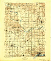
1901 Map of Rock Island
USGS Topo · Published 1901About this map
The Wapsi Pinicon River snakes across this turn-of-the-century landscape, carving a meandering path through eastern Iowa and into the Mississippi River. This survey captures the region at the peak of the railroad era, dominated by a dense grid of competing lines such as the Chicago Rock Island and Pacific R. R. and the Chicago Milwaukee and St. Paul R. R.. These tracks fueled the growth of numerous small prairie towns, from Oxford Junction in the north to Walcott and Durant further south.
Find a feature on this map
99 named features on this map. Tap any name to fly to it.
Don’t see what you’re looking for? This feature index may not catch every label — zoom into the map to look around manually.
Map Details
Editions of this 1901 Rock Island Map
2 editions found
Other maps of this area

1889 · Tipton
USGS Topo · 1:62,500

1890 · Durant
USGS Topo · 1:62,500

1890 · Tipton
USGS Topo · 1:62,500

1891 · DeWitt
USGS Topo · 1:62,500

1891 · Davenport
USGS Topo · 1:62,500

1891 · Monticello
USGS Topo · 1:62,500

1891 · Maquoketa
USGS Topo · 1:62,500

1891 · Wilton Junction
USGS Topo · 1:62,500

1891 · Baldwin
USGS Topo · 1:62,500

1892 · Wheatland
USGS Topo · 1:62,500