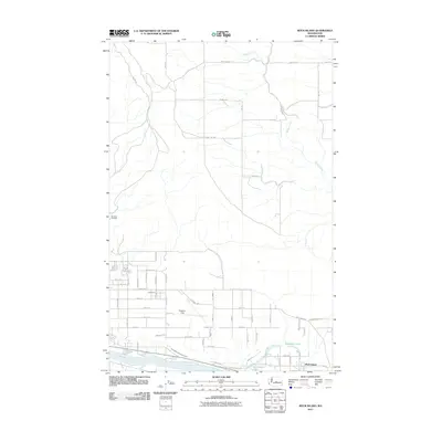
2011 Map of Rock Island
USGS Topo · Published 2011About this map
The Columbia River defines the southern boundary of this Washington landscape, where the settlement of Rock Island sits near the riverbank. This 2011 survey captures the area’s mixed agricultural and aviation character, notably centered on Pangborn Field. The irrigation infrastructure required for this region’s development is evident in the Wenatchee Reclamation Ditch, which cuts through the southern reaches of the quadrangle. North of the river, the terrain is defined by a grid of rural routes such as Clark Rd SW and SW Road 11, serving a landscape carved by the meandering path of Beaver Creek. Local history is anchored by the Hamilton Cemetery to the west and recreational water bodies like Blue Heron Lake and Hideaway Lake near the river’s edge.
Find a feature on this map
58 named features on this map. Tap any name to fly to it.
Don’t see what you’re looking for? This feature index may not catch every label — zoom into the map to look around manually.
Map Details
Editions of this 2011 Rock Island Map
This is the sole edition of this map. No revisions or reprints were ever made.
Other maps of this area

1901 · Chelan
USGS Topo · 1:125,000

1912 · Malaga
USGS Topo · 1:48,000

1913 · Wenatchee
USGS Topo · 1:62,500

1914 · Malaga
USGS Topo · 1:62,500

1915 · Wenatchee
USGS Topo · 1:62,500

1920 · Colockum Pass
USGS Topo · 1:125,000

1922 · Colockum Pass
USGS Topo · 1:125,000

1957 · Wenatchee
USGS Topo · 1:250,000
1966 · Malaga NE
USGS Topo · 1:24,000

1966 · Rock Island
USGS Topo · 1:24,000