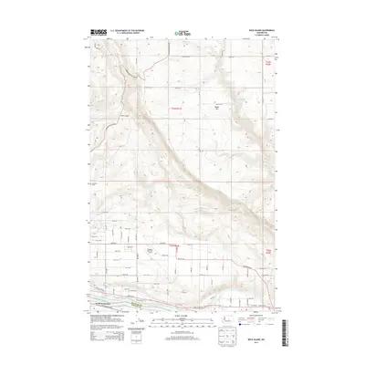
2014 Map of Rock Island
USGS Topo · Published 2014About this map
The Columbia River carves the western boundary of this landscape, separating South Wenatchee and the Douglas Co Chelan Co line from the town of Rock Island. This 2014 survey documents a critical junction of infrastructure and irrigation, anchored by the Pangborn Memorial Airport and the complex network of the Wenatchee Reclamation Ditch. The geography transitions abruptly from the level plains of the river valley to the steep elevations of Badger Mtn, where deep incisions like Sand Canyon reveal the area's volcanic and glacial heritage. Local history is anchored by the Hamilton Cem on the western slopes, while the riverside is dotted with modern recreational and industrial landmarks including Blue Heron Lake, Rock Island Lake, and Hideaway Lake. The grid-like street system of the valley floor, featuring Grant Rd and Quincy Hwy S, contrasts sharply with the winding access routes like Badger Mountain Rd that navigate the higher terrain.
Find a feature on this map
64 named features on this map. Tap any name to fly to it.
Don’t see what you’re looking for? This feature index may not catch every label — zoom into the map to look around manually.
Map Details
Editions of this 2014 Rock Island Map
This is the sole edition of this map. No revisions or reprints were ever made.
Other maps of this area

1901 · Chelan
USGS Topo · 1:125,000

1912 · Malaga
USGS Topo · 1:48,000

1913 · Wenatchee
USGS Topo · 1:62,500

1914 · Malaga
USGS Topo · 1:62,500

1915 · Wenatchee
USGS Topo · 1:62,500

1920 · Colockum Pass
USGS Topo · 1:125,000

1922 · Colockum Pass
USGS Topo · 1:125,000

1957 · Wenatchee
USGS Topo · 1:250,000
1966 · Malaga NE
USGS Topo · 1:24,000

1966 · Rock Island
USGS Topo · 1:24,000