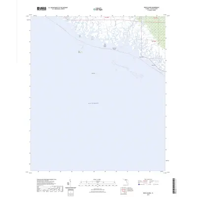
2024 Map of Rock Islands
USGS Topo · Published 2024About this map
The Fenholloway River and Henderson River meet the salt marshes of Taylor County in this coastal survey, where the intricate network of tidal creeks and bayous transitions into the open Gulf of Mexico. This low-lying maritime landscape is defined by its barrier features and isolated hammocks, including Rock Island and the neighboring Little Grassy Island and Big Grassy Island. The area is a focal point for modern coastal recreation, marked by the long-distance Florida Circumnavigational Paddling Trl and the Big Bend Historic Saltwater Trl that navigate the labyrinth of waterways like Cedar Island Bayou and Pitts Creek. Small landforms such as Rock Point, Stake Point, and the offshore Bird Rock provide essential navigation references for this undeveloped stretch of the Florida coastline, while drainage features like Regular Creek and Cut Off Creek illustrate the complex hydrology of the Gulf coast's marshy fringe.
Find a feature on this map
18 named features on this map. Tap any name to fly to it.
Don’t see what you’re looking for? This feature index may not catch every label — zoom into the map to look around manually.
Map Details
Editions of this 2024 Rock Islands Map
This is the sole edition of this map. No revisions or reprints were ever made.
Other maps of this area

1954 · Hampton Springs
USGS Topo · 1:24,000

1954 · Okefenokee Slough
USGS Topo · 1:24,000

1954 · Gainesville
USGS Topo · 1:250,000

1954 · Valdosta
USGS Topo · 1:250,000

1955 · Snipe Island
USGS Topo · 1:24,000

1955 · Rock Islands
USGS Topo · 1:24,000

1955 · Manlin Hammock
USGS Topo · 1:24,000
1956 · Hampton Springs
USGS Topo · 1:25,000

1958 · Valdosta
USGS Topo · 1:250,000

1958 · Gainesville
USGS Topo · 1:250,000