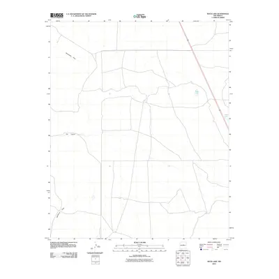
2010 Map of Rock Lake
USGS Topo · Published 2010About this map
Red Canyon defines the central terrain of this Torrance County landscape, where seasonal drainage patterns and isolated water bodies dictate the geography of the high plains. The intermittent Rattlesnake Draw and McGillivray Draw illustrate the natural runoff routes through this arid region, converging toward the central and southern portions of the quadrangle. In an area where water is a vital resource, named features like Rock Lake and Texas Lake stand out as prominent landmarks amidst a network of secondary roads and section lines. This survey captures the rural character of the New Mexico interior in the early 21st century, showing how the sparse infrastructure interacts with the natural depressions and canyons of the local topography.
Find a feature on this map
5 named features on this map. Tap any name to fly to it.
Don’t see what you’re looking for? This feature index may not catch every label — zoom into the map to look around manually.
Map Details
Editions of this 2010 Rock Lake Map
This is the sole edition of this map. No revisions or reprints were ever made.
Other maps of this area

1894 · Lamy
USGS Topo · 1:125,000

1954 · Santa Fe
USGS Topo · 1:250,000

1954 · Fort Sumner
USGS Topo · 1:250,000

1958 · Fort Sumner
USGS Topo · 1:250,000

1958 · Santa Fe
USGS Topo · 1:250,000

1960 · Lobo Hill
USGS Topo · 1:62,500

1960 · Stanley
USGS Topo · 1:62,500
1966 · El Cabo
USGS Topo · 1:24,000
1966 · Clines Corners
USGS Topo · 1:24,000
1978 · Waller Ranch
USGS Topo · 1:24,000