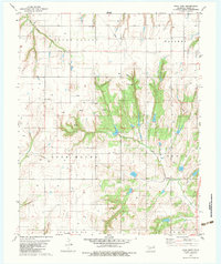
1979 Map of Rock Mary
USGS Topo · Published 1983About this map
Rock Mary stands as a prominent sandstone landmark in this Caddo County landscape, surrounded by the shifting terrain of Mound Valley and the distinctive elevations of Lone Mound. During the late 1970s, this area of western Oklahoma was characterized by a developing energy infrastructure, evidenced by the numerous Gas Wells, Oil Wells, and a significant Pipeline cutting across the central hills. The social fabric of the rural community is anchored by Cedar Valley Ch, situated near the headwaters of Dead Woman Creek. The eastern portion of the sheet is defined by the deep incisions of Sugar Creek, which winds through the named topographical zones of Waconda and Cedar. This map captures a moment when traditional land use in the Red Bed Plains met the industrial demands of the mid-century petroleum boom.
Find a feature on this map
20 named features on this map. Tap any name to fly to it.
Don’t see what you’re looking for? This feature index may not catch every label — zoom into the map to look around manually.
Map Details
Editions of this 1979 Rock Mary Map
2 editions found
Other maps of this area

1942 · Geary
USGS Topo · 1:62,500

1951 · Binger
USGS Topo · 1:62,500

1955 · Clinton
USGS Topo · 1:250,000

1957 · Clinton
USGS Topo · 1:250,000

1961 · Eakly
USGS Topo · 1:62,500

1964 · Weatherford
USGS Topo · 1:62,500

1979 · Hinton
USGS Topo · 1:24,000

1979 · Sickles
USGS Topo · 1:24,000
1979 · Binger
USGS Topo · 1:24,000
1979 · Geary South
USGS Topo · 1:24,000