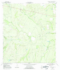
1969 Map of Rockaway Creek
USGS Topo · Published 1992About this map
The Frio River and its network of ephemeral tributaries define this South Texas landscape in the late 1960s. Surveyed by the Geological Survey and the Texas Water Development Board, the map captures a region primarily shaped by ranching and early petroleum development. In the western portion, the small outpost of Muerto Camp sits near the banks of Muerto Creek, while several Gas Wells and an Oil Well scattered across the quadrangle suggest the emerging industrial footprint of the era. The terrain is a complex web of seasonal drainages, including Rockaway Creek, Galinda Creek, and Esperanza Creek, which carve through the plains toward the main river channel. Artificial water sources like Middle Mule Tank emphasize the importance of water management in this arid environment, while the presence of a Gravel Pit and multiple pipelines reflect the infrastructure supporting McMullen County's mineral and transit needs.
Find a feature on this map
21 named features on this map. Tap any name to fly to it.
Don’t see what you’re looking for? This feature index may not catch every label — zoom into the map to look around manually.
Map Details
Editions of this 1969 Rockaway Creek Map
2 editions found
Other maps of this area

1925 · Tilden No. 1
USGS Topo · 1:48,000

1930 · Tilden
USGS Topo · 1:62,500

1942 · Fowlerton
USGS Topo · 1:62,500

1942 · Tilden
USGS Topo · 1:62,500

1953 · Crystal City
USGS Topo · 1:250,000

1955 · Crystal City
USGS Topo · 1:250,000

1956 · Hindes
USGS Topo · 1:62,500

1956 · Franklin Settlement
USGS Topo · 1:62,500

1956 · Fowlerton
USGS Topo · 1:62,500

1961 · Crystal City
USGS Topo · 1:250,000