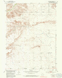
1950 Map of Rockeagle
USGS Topo · Published 1991About this map
Harmony Heights and the wide expanse of Goshen Hole dominate this corner of Wyoming, where the high plains meet the edges of the Missouri River Basin development. The landscape is marked by the legacy of frontier defense, notably the expansive Fort Laramie Military Reservation (Abandoned) which occupies much of the northern territory. Local landmarks such as Doty Hill and Horseshoe Butte rise above the drainage of Deer Creek and Cherry Creek. Settlers and ranchers left their mark on this terrain at the Old Doty Ranch Site and the small settlement of Rockeagle. The map reveals the infrastructure of early ranching and mapping, including scattered Windmills and numerous survey markers such as Vabm 4752. A solitary Grave north of Deer Creek serves as a quiet reminder of the area's early inhabitants.
Find a feature on this map
19 named features on this map. Tap any name to fly to it.
Don’t see what you’re looking for? This feature index may not catch every label — zoom into the map to look around manually.
Map Details
Editions of this 1950 Rockeagle Map
5 editions found
Other maps of this area

1896 · Patrick
USGS Topo · 1:125,000

1896 · Hartville
USGS Topo · 1:125,000

1899 · Goshen Hole
USGS Topo · 1:125,000

1901 · Hartville
USGS Topo · 1:125,000

1950 · Rockeagle
USGS Topo · 1:24,000

1950 · Fort Laramie
USGS Topo · 1:24,000

1950 · Register Cliff
USGS Topo · 1:24,000

1951 · Eagles Nest
USGS Topo · 1:24,000

1952 · Register Cliff
USGS Topo · 1:24,000

1952 · Fort Laramie
USGS Topo · 1:24,000