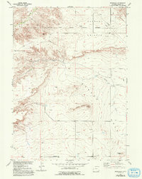
1950 Map of Rockeagle
USGS Topo · Published 1993About this map
The Fort Laramie Military Reservation (Abandoned) dominates the northern landscape of this Goshen County survey, reflecting the area's transition from 19th-century frontier defense to a 20th-century ranching and infrastructure corridor. This plateau, known as Harmony Heights, rises above the drainage of Deer Creek and Cherry Creek, where modern utility lines and a pipeline now cross the former military grounds. Evidence of earlier settlement remains at the Old Doty Ranch Site and the small station at Rockeagle, while prominent landmarks like Doty Hill and Horseshoe Butte define the topography south of the creeks. The presence of numerous Windmill sites across the flats suggests a reliance on groundwater to support the livestock operations that replaced the military garrison. This 1950 data, revised in the early 1990s, provides a clear view of the high plains just before late-century development further altered the rural landscape.
Find a feature on this map
16 named features on this map. Tap any name to fly to it.
Don’t see what you’re looking for? This feature index may not catch every label — zoom into the map to look around manually.
Map Details
Editions of this 1950 Rockeagle Map
5 editions found
Other maps of this area

1896 · Patrick
USGS Topo · 1:125,000

1896 · Hartville
USGS Topo · 1:125,000

1899 · Goshen Hole
USGS Topo · 1:125,000

1901 · Hartville
USGS Topo · 1:125,000

1950 · Rockeagle
USGS Topo · 1:24,000

1950 · Fort Laramie
USGS Topo · 1:24,000

1950 · Register Cliff
USGS Topo · 1:24,000

1951 · Eagles Nest
USGS Topo · 1:24,000

1952 · Register Cliff
USGS Topo · 1:24,000

1952 · Fort Laramie
USGS Topo · 1:24,000